Agtech: Putting a price on a blade of grass
A LiDAR pasture tool promises big profitability gains, but the economics, accuracy data and farm-type fit remain largely unanswered.
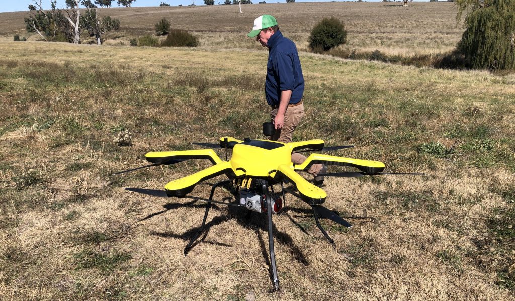
The assumption baked into most coverage of this technology is simple: if you can measure pasture more precisely, you will make more money growing and grazing it. That sounds obvious right up until you ask what the measuring equipment costs, how it compares to tools graziers already own, and whether the farm doing the measuring looks anything like the one the trial was built around. Put those questions to the LiDAR pasture tool and the picture gets considerably less tidy.
1. What actually has to be bought and flown
A drone-mounted LiDAR system is not a single purchase so much as a stack of them. There is the airframe capable of carrying a sensor payload heavier than the consumer drones most farmers already own, the LiDAR unit itself, a ground-control or RTK positioning setup to keep the point cloud accurate, and the processing software that turns millions of laser returns into a usable 3D pasture map. None of these components are consumer-grade commodity items in the way a rising plate meter or a soil probe is. Add in battery packs, spare props, insurance, and the operator training needed to fly a complex payload safely over livestock, and the up-front capital outlay sits in a different bracket altogether from the tools most grazing operations currently budget for.
Then there is the recurring cost that rarely makes it into the coverage: someone still has to fly the paddocks, download and process the data, and interpret the output, every time a measurement is wanted. That is a labour and skill cost on top of the hardware, and it does not disappear once the drone is paid off.
2. The cheaper alternatives already sitting in the shed
Graziers already have three low-cost ways to estimate pasture cover, and all three have been in paddocks for years. Satellite NDVI services charge a subscription fee and need no equipment purchase at all; the farmer logs in and reads a greenness map. Rising plate meters cost a fraction of any drone and are pushed through pasture by hand, giving an instant height-to-biomass estimate that generations of dairy and beef farmers have calibrated against their own paddocks. Capacitance probes sit in a similar price bracket, swept through the sward in seconds.
None of these tools build a true 3D model of the pasture canopy, and none of them can distinguish standing dead material from green leaf the way a laser scan in theory can. But they are cheap, familiar, require no flying licence, and already have years of farmer trust behind them. For the LiDAR rig to earn its keep, it has to beat not just the accuracy of these tools but the accuracy gain multiplied by the cost difference — and that sum has not been shown publicly in a way an ordinary farmer could check against their own ledger.
3. The accuracy question nobody has answered in percentage terms
Manual cut-and-weigh sampling is the existing yardstick used to check any pasture-measuring tool, LiDAR included, and it is understood that the drone scans are being validated against it. What has not been published is the actual size of the gap: how many kilograms of dry matter per hectare the LiDAR estimate is out by, on average, compared with a hand-cut quadrat. Without that figure, a farmer cannot tell whether the new tool is meaningfully more accurate than a well-calibrated plate meter, which also carries its own known margin of error built up over decades of use. A biomass estimate that looks impressively precise on a screen is not useful if its error range against the cut-and-weigh benchmark is no tighter than the cheaper tool it is meant to replace.
4. A profitability figure built on one type of farm
The headline profitability lift being discussed sits at a double-digit range and is attached specifically to dairy operations. Dairy pasture economics are unusual: milking herds are rotated through small paddocks on tight cycles, grass quality changes daily milk yield in a way that is immediately visible in the vat, and even small improvements in grazing timing compound quickly across a herd that is measured and managed every single day. That is the environment in which a highly granular measurement tool has the most obvious payoff, because the decisions being improved are made constantly and the feedback loop is short.
Nothing in what has been described demonstrates that the same percentage gain, or anything close to it, would show up on a beef or sheep enterprise, where grazing decisions are made far less frequently and the economic unit of improvement is a seasonal liveweight gain rather than a daily litre count.
5. Where beef and sheep grazing likely sees little of the gain
Extensive beef and sheep operations typically move stock between large paddocks on a weekly or fortnightly rhythm rather than a daily one, and the per-animal value of marginal grazing precision is smaller than in a milking herd. A tool that can measure pasture cover to a fine resolution is of limited use if the farm’s management cycle only acts on that information once every week or two. In that setting, a cheap plate meter reading taken at the gate before shifting mobs may already capture most of the decision-relevant information, and the gap between that and a drone-built 3D canopy model narrows sharply in economic terms, even if it remains wide in technical terms.
6. Small acreage and mixed cropping operations: the wrong shape of farm
Three types of operation look particularly unlikely to see anything near the claimed profitability lift. Small-acreage grazing blocks simply do not have enough paddock area to spread the per-hectare cost of a drone survey thinly enough to matter; the fixed cost of owning or hiring the rig overwhelms any marginal grazing gain. Non-dairy operations, as above, make fewer, lower-frequency grazing decisions, so the value of high-resolution, high-frequency data drops. And mixed cropping farms that only run livestock on a rotational or opportunistic basis, grazing stubble or a cover crop between cash crops, have neither the paddock infrastructure nor the daily management habit that would let them act on fine-grained pasture data even if they had it. For all three, a satellite subscription or an existing plate meter is likely to remain the rational choice.
7. Terrain, wet grass and mixed species: the conditions that matter most
Laser scanning depends on a clean, repeatable line of sight to the canopy surface. Steep or undulating country distorts the geometry of the scan unless the flight path and ground-control setup are adjusted for it, adding to the processing burden. Wet pasture reflects light differently than dry pasture, which can shift a sensor’s estimate of canopy height and density in ways that need separate calibration. And a paddock with a genuine mix of species, clover sitting low under taller ryegrass, weeds of varying height scattered through the sward, is a much harder surface for any single height-based model to read accurately than the uniform stands often used in early trials. None of these conditions are rare in Australian grazing country; they are closer to the norm than the exception, which makes real-world performance a bigger open question than the trial results alone can answer.
8. When, and at what price, an ordinary farmer could actually buy this
What is missing from the public discussion so far is any commercial timeline. There is no indication of when a version of this system, packaged for a working farm rather than a research project, would be available to buy or hire, and no retail price attached to that eventual product. Until both exist, any comparison between this tool and satellite NDVI subscriptions or plate meters is necessarily theoretical, because one side of the comparison has a price tag today and the other does not.
The research behind this tool may well sharpen pasture measurement in ways cut-and-weigh sampling and satellite imagery cannot match. But a blade of grass only has a price worth paying for if the tool measuring it costs less, or earns more, than the instrument already in the shed. For a lot of Australian grazing country, that comparison has not yet been made in public, and until it is, the sensible move for most farms is to keep the plate meter close at hand.

Flock & Breeding Desk
Writing on breeding, lambing, nutrition and day-to-day flock management for Wiltshire Horn producers.